GEONEON WILDFIRE SEVERITY INDEX SAMPLE
GET YOUR FREE SAMPLE OF GEONEON WILDFIRE SEVERITY INDEX
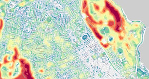
Explore Geoneon’s Wildfire Severity Index and experience the power of advanced AI and high-resolution satellite imagery in predicting wildfire severity. Whether you are involved in emergency management, urban planning, infrastructure protection, or environmental conservation, our sample will showcase the precision and insights our technology provides. Discover how our Wildfire Severity Index can enhance your approach to wildfire long-term preparedness.
Why Download the Sample?
- Evaluate the quality of Geoneon’s Wildfire Severity Index for your specific needs.
- Visualise how our data-driven predictions can inform and improve your wildfire management strategies.
- Understand the value of current, high-resolution insights that set Geoneon apart from traditional methods.
Complete the form below to access your free sample of Geoneon’s Wildfire Severity Index. Start making informed, proactive decisions today!